ფაილი:African-civilizations-map-pre-colonial.svg

თავდაპირველი ფაილი (ფაილი SVG, ნომინალურად 1 390 × 1 295 პიქსელი, ფაილის ზომა: 488 კბ)
| ესკიზის შექმნის შეცდომა: | ეს ფაილი მდებარეობს Wikimedia Commons სერვერზე. იხილეთ მისი აღწერის გვერდი სრული ინფორმაციისთვის. |
შეცდომა: სურათი მცდარია ან არ არსებობს |
გადასვლა ფაილის გვერდზე |
სარჩევი
რეზიუმე
| აღწერაAfrican-civilizations-map-pre-colonial.svg |
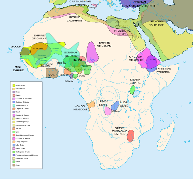
Africa History Atlas Diachronic map showing pre-colonial cultures of Africa (spanning roughly 500 BCE to 1500 CE) This map is "an artistic interpretation" using multiple and disparate sources. |
| თარიღი | |
| წყარო | პირადი ნამუშევარი |
| ავტორი | Jeff Israel (ZyMOS) |
| სხვა ვერსიები |
Derivative works of this file: African-civilizations-map-imperial.png
|
Civilizations
These civilizations are shown on the map above
Mali Empire (done):
        [4], [5], [6], [7], [8](1300), 14

Nok Culture(done):
        http://perso.orange.fr/miltiade/Civilisation_de_Nok.htm
        [5]

Fulani empire (aka sokoto empire, Sokoto Calphate, Fulani Empire of Sokoto)  (fulani people are different) (done):
        [2], [10e], [11e]
Akan States (generric term for states with the akan people)(Done):
 [7],
Benin: (done)
        [7],[14],[16]
Hausa (done)
        [7], [10],[16]

Kingdon of Kangaba (1000AD?) (done)
        [8](1235)

Christian Ethiopia(done)
        [5]

Songhai Empire (done)
        http://commons.wikimedia.org/wiki/Image:Mapa_shonghai.svg
        [3], [4], [5], [6], [7], [8](1300), [16]
        http://www.zum.de/whkmla/histatlas/westafrica/haxmali.html
        http://empathosnationenterprises.com/Consulate/EN-Library/Black-Studies/afempire.html

Empire of Ghana (done):
        [4], [5], [6], [7]

Wolof: (15th century) (done)
        [2],[2c],[14]

Empire of Kanem:(done)
        [15]

Fatimid caliphate(done) 909-1171AD
        [2b],[6b]

Ayyubid dynasty (done) 1171-1250ad
        [1b], [5e], [6e]

Umayyad Caliphate (done) 661-750
        [5b]

Yoruba yorubaland    (done)
        [4b],[2c]

Igbo    (done)
        [4b],

Great Zimbabwe (done):
        [5], [7]

Kingdom of aksum (Axum?) 1bc-7ad  (done)
        [12b],[14b],[15b]

Kongo Kingdom     (done)
        [1c], [2c],[15]

Luba State (done) 15-19th century
        [2c],[4c]

Lunda State (done) 15-19th century
        [2c],[4c],[16]

Carthaginian Empire(done) (220BCE) Carthage
        [2c], [3c]

Persian Achaemenid Empire (done)
        [2e],3e].4e],[

THE PTOLEMIES (done)
        [8e], [9e]
Civilizations to be added
These civilizations have not been added because the borders have not yet been confirmed, or there is some uncertainty if they are a true civilization. Please add them to the map if you are able to define the borders of these civilizations.
Mane (1000-2000)(city) [41]

Kano (independent city-state) (1000-1903):
 [14]

Kaarta (kingdom of Kaarta) (1753-1854):
 [14]

Macina (Macina Empire) (aka Dina of Massina, Sise Jihad state, and Caliphate of Hamdullahi) (1818-1862):
 [14]

Segou (city 1620):
 [14]

Kingdom of Fouta Djallon (Futa Djalon or Kingdom of Fuuta Jallon):
 [14]

Hausa Bakwai (initial stage Hausa):
 [11e]

Wassoulou Empire (Ouassoulou) (1878 - 1898) :
 [14]

Kénédougou Kingdom (Kenedougou) (1650-1898):
 [14]

Ouagadougou (15th century CITY):
 [14]

Ashanti Kingdom:
	[14]

Dahomey:
	[14]

Gando (16th century town):
	[14]

kingdom of Takrur (c. 800 - c. 1285) :
	[8](1300), [13]

Oyo empire (1400-1796)


Bornu Empire (1396-1893):
        [2],[15], [10e]

Bornu-Kanem (a portion of kanem history where they merged):
	[7],[2c]

Wodaabe (a people of africa):
	[10]

Mamluk Sultanate of Egypt (1174-1820):
	[2],[12],

Kush?Kushite kingdom?:

Axum (see kingdom of aksum):

Buganda kingdom (changed to Unganda, but remained as Buganda people):

Lozi???:

Malawi Empire (late 15th centure and converted to Malawi Contry):

Kilwa (Kilwa Kisiwani, 9th century,  is an Islamic community is present day tanzania):
	[2c]

Abyssinia???:
        [2], [7]

Soha????:
        [2],

Nubia (Makuria, Nobatia, Alodia kingdom):
	[7],

Kingdom of Kerma(2500BC-1520BC):

=North Central=

Sahariano??:
	[1],

Maban????????:
        [1],

Fur(a people:
        [1],

Sudanes Central (language Central Sudanic):
        [1],

=East Central=

Sudanes Meridional???:
        [1],

Berta(language>:
        [1],

Kunama(a people):
        [1],

Komuz???instument:
        [1],

Aksumite Civilization
	[7b], [9b(maybey], [13b(aksum)]

Kingdom of Sheva???
	[8b]

Egypt
	[10b]

JolofEmpire (also called Dyolof or Wolof), wolof should be changed to this:
	[11b]


Meroe(city, capital of Kushitic Kingdom))
	[12b]

Bantu(ethnic group)
	[12b]

Khoisan(ethnic group)
	[12b]

Almoravid Empire
	[5c], [1f]

Monomotapa
	[2c],[16]

Lozi
	[2c]

Zulu Kingdom
	[2c]

Merina
	[2c]

Malawi
	[2c]

Rawanda
	[2c]

Buganada
	[2c]

Kazembe
	[4c]


Punt (3000BC-1000BC):
	location lost in time

D'mt (800BC-100BC):


Gudit (1000AD):

Zagwe Dynasty (1000-1268AD):
	[6e]

Solomonic dynasty (1270-1974AD)

Himyar:
	[1d]

Qataban:
	[1d]

Saba:
	[1d]

Hadhramaut:
	[1d]

Thutmoses 1
	[1e]

Ramesses II
	[1e]

Assurbanipal, empire of
	[7e]

Mbunda Kingdom
	[12e], [13e]
Editing this page and map
Suggestions before editing this map: Be sure to confirm it with multiple sources, and that it would be considered a true civilization. Also if you add to the map please name the layers and objects to keep it organized. A lot of the civilizations on this page do not have the times they existed. If this could be added it would be very beneficial. Then the map could be easily split into eras.
References
The original map came from
- Image:Africa map political-fr.svg, by Eric Gaba.
- some of the features where removed to simplify it.
- [1] http://www.proel.org/mundo/songhai.htm
- [2] http://afriquepluriel.ruwenzori.net/africa-atlas22.htm archive copy at the Wayback Machine
- [3] https://www.metmuseum.org/toah/hd/sghi/hd_sghi.htm
- [4] http://buckley6thgradehistory.pbwiki.com/AceWiki
- [5] "The Harper Atlas of World History", 1987, William Collins Son & Co Ltd, New York, pg131
- [6] https://www.ucalgary.ca/HIST/tutor/imageislam/westAfrica.gif
- [7] http://empathosnationenterprises.com/Consulate/EN-Library/Black-Studies/afempire.html
- [8] http://www.plu.edu/~allenjjj/img/The%20Mali%20Empire.jpg archive copy at the Wayback Machine
- [9] http://www.mythinglinks.org/afr~subsahara~HausaFulani.html
- [10] http://www.uiowa.edu/~africart/toc/countries/Niger.html
- [11] is [6b]
- [12] http://www.meitmuseum.org/toah/hd/maml/hd_maml.htm
- [13] http://www.uv.es/~ivorra/Historia/AEM/SigloXg.htm
- [14] http://www.zum.de/whkmla/histatlas/westafrica/haxmali.html
- [15] http://www.loyno.edu/~seduffy/MapImages/Africa1500-1800-display.jpg
- [16] http://www.flotte2.com/1800AD.htm archive copy at the Wayback Machine
- [1b] https://www.metmuseum.org/toah/hd/ayyu/hd_ayyu.htm
- [2b] https://www.metmuseum.org/toah/hd/fati/hd_fati.htm
- [3b] https://www.metmuseum.org/toah/hd/pave/hd_pave.htm
- [4b] https://www.metmuseum.org/toah/hd/pave/hd_pave.htm
- [5b] https://www.metmuseum.org/toah/hd/umay/hd_umay.htm
- [6b] http://countryturkmenistan.tripod.com/index.blog?from=20050708
- [7b] http://en.wikipedia.org/wiki/Image:LocationAksumiteEmpire.png
- [8b] http://www.imninalu.net/tribes2.htm archive copy at the Wayback Machine
- [9b] http://www.freewebs.com/eritrea2001/infocenter.htm
- [10b] http://www.iziko.org.za/sh/resources/egypt/history_new_kingdom.htm
- [11b] http://www.geocities.com/jbenhill/timeline.html
- [12b] http://p083.ezboard.com/Not-all-of-Africans-belong-to-Bantu-or-Negroid-race/fbalkansfrm57.showMessage?topicID=56.topic[dead link]
- [13b] http://www.homestead.com/wysinger/aksum.html
- [14b] http://news.asmarino.com/TomasMebrahtu/Images/Map_.jpg archive copy at the Wayback Machine
- [15b] http://en.wikipedia.org/wiki/Image:GDRT230.jpg
- [16b] http://www.bible.ca/islam/islam-aksum-map-0-700ad.jpg
- [1c] https://www.metmuseum.org/toah/hd/acko/acko_d1map.htm
- [2c] http://exploringafrica.matrix.msu.edu/teachers/curriculum/m7b/activity1.php archive copy at the Wayback Machine
- [3c] http://www.livius.org/cao-caz/carthage/carthage.html
- [4c] http://concise.britannica.com/ebc/article-9370655/Luba-Lunda-states[dead link]
- [5c] http://www.allempires.com/forum/forum_posts.asp?TID=6586&PN=1
- [1e] http://www.iziko.org.za/sh/resources/egypt/history_new_kingdom.htm
- [2e] http://commons.wikimedia.org/wiki/Image:Achaemenid_Empire.jpg
- [3e] http://commons.wikimedia.org/wiki/Image:Carte_empire_ach%C3%A9m%C3%A9nide.png
- [4e] http://commons.wikimedia.org/wiki/Image:Persian_empire_490bc.gif
- [5e] http://commons.wikimedia.org/wiki/Image:Ayyubids1189.png
- [6e] http://commons.wikimedia.org/wiki/Image:Ayyubid.png
- [7e] http://www.fortunecity.com/tatooine/acegarp/898/10000bc601.htm archive copy at the Wayback Machine
- [8e] http://www.transanatolie.com/English/Turkey/Anatolia/Hellens/hellens.htm
- [9e] http://www.unc.edu/awmc/downloads/aegyptusPtolSml.jpg archive copy at the Wayback Machine
- [10e] http://www.amanaonline.com/Sokoto/table_of_content.htm
- [11e] http://www.britannica.com/ebi/art-3910?articleTypeId=1
- [12e] http://commons.wikimedia.org/wiki/File:Mbunda_Kingdom_Map.png
- [13e] https://www.mbundakingdom.org/ archive copy at the Wayback Machine
- [1x] http://commons.wikimedia.org/wiki/Image:Africa_15.PNG
- [2x] http://commons.wikimedia.org/wiki/Image:Africa_13.PNG
ლიცენზია

|
თქვენ შეგიძიათ გაავრცელოთ ან შეცვალოთ დოკუმენტი GNU Free Documentation ლიცენზიის 1.2 ან უფრო გვიანდელი ვერსიის პირობების თანახმად, რომელიც გამოქვეყნებულია თავისუფალი პროგრამული უზრუნველყოფის ფონდის მიერ, შეუცვლელი განყოფილებების გარეშე, პირველ და ბოლო გვერდებზე განთავსებულ ტექსტებზე. ლიცენზიის ასლი არის განთავსებული განყოფილებაში სახელად GNU Free Documentation License.http://www.gnu.org/copyleft/fdl.htmlGFDLGNU Free Documentation Licensetruetrue |
- თქვენ თავისუფლად შეგიძლიათ:
- ნამუშევრის გაზიარება – ნამუშევრის კოპირება, გავრცელება და გადაცემა.
- შექმნათ დაფუძნებულები – ნამუშევრის შესწორება
- შემდეგი პირობებით:
- მოხსენიება – თქვენ უნდა მიუთითოთ წყაროს შემქმნელი იმ გზით, რომელიც დანიშნა ავტორმა ან საავტორო უფლებების მფლობელმა. მაგრამ არა ისე, თითქოს წყაროს ავტორი მხარს გიჭერთ თქვენ ან დაუჭირა თქვენს მიერ შექმნილ ნაწარმოებს.
- გავრცელება იგივე პირობებეით – თუ თქვენ ცვლით, ან ქმნით ახალ ნაშრომს ამ ნამუშევრის გამოყენებთ, თქვენ გაქვთ უფლება გაავრცელოთ იგი იგივე ან შესაბამისი ლიცენზიით, რომლითაც ვრცელდება წყარო.
Captions
Items portrayed in this file
გამოსახული ობიექტი
copyrighted ინგლისური
1 მაისი 2007
source of file ინგლისური
original creation by uploader ინგლისური
media type ინგლისური
image/svg+xml
checksum ინგლისური
458dcae2fb4eb4a66837ee9cd5c1e539750e7c18
data size ინგლისური
498775 ბაიტი
1295 pixel
1390 pixel
ფაილის ისტორია
დააწკაპუნეთ თარიღზე/დროზე ფაილის დასათვალიერებლად, როგორც ის მაშინ გამოიყურებოდა.
| თარიღი/დრო | მინიატიურა | ზომები | მომხმარებელი | შენიშვნა | |
|---|---|---|---|---|---|
| მიმდინარე | 07:49, 16 თებერვალი 2024 |  | 1 390×1 295 (488 კბ) | wikimediacommons>Ahiise2 | Changed "Bachwezi Empire" to "Kitara Empire" to be consistent with other versions of the file |
ბმულები
ამ ფაილზე ბმული მოცემულია შემდეგ გვერდებზე:
მეტამონაცემები
ეს ფაილი შეიცავს დამატებით ინფორმაციას, რომელიც სავარაუდოდ ამ სურათის შექმნისას გამოყენებულმა ციფრულმა კამერამ ან სკანერმა დაამატა. თუ ფაილის ორიგინალს სახე ეცვალა, ზოგიერთი დეტალი შესაძლოა მოდიფიცირებულ სურათს არ ეხამებოდეს.
| სიგანე | 1390 |
|---|---|
| სიმაღლე | 1295 |


