ფაილი:Royal Air Force Bomber Command, 1942-1945. CL3400.jpg

თავდაპირველი ფაილი ((2 143 × 1 772 პიქსელი, ფაილის ზომა: 1,56 მბ, MIME ტიპი: image/jpeg))
| ეს ფაილი მდებარეობს Wikimedia Commons სერვერზე. იხილეთ მისი აღწერის გვერდი სრული ინფორმაციისთვის. |
 |
გადასვლა ფაილის გვერდზე |
რეზიუმე
| შემსრულებელი |
Dowd J (Fg Off), Royal Air Force official photographer |
|||
| აღწერა |
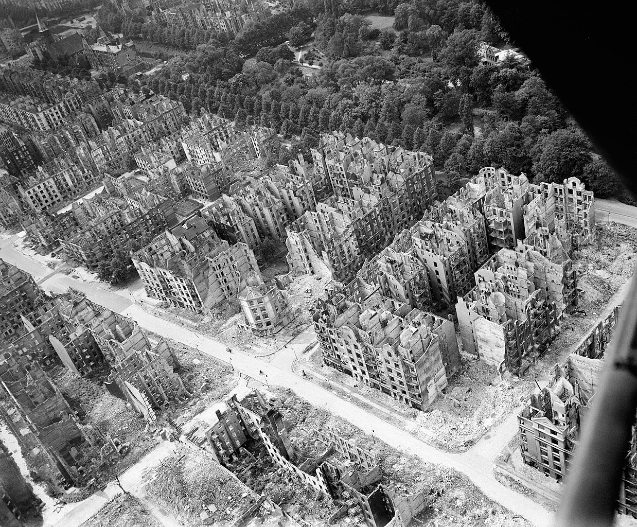
Deutsch: Blick von Südosten nach Nordwesten über beim durch britische Bomben ausgelösten Feuersturm 27./28. Juli 1943 ausgebrannte Wohnhäuser: Die Hauptstraße im Bild ist der Eilbeker Weg, die Querstraßen, rechts beginnend, Kleiststraße, Rückertstraße (südl. des Eilbeker Wegs ist eine Sperrmauer zu sehen, die die zerstörte und daher unbewohnte Feuersturmzone abriegelt), Seumestraße (mit Haus Seumestr. Nr. 44 auf der östlichen Straßenseite, einziges unzerstörtes Haus im sichtbaren Abschnitt der Straße, bis heute erhalten), Wielandstraße, Friedrichsberger Straße, in diese mündet per T-Kreuzung die Auenstraße. Am oberen Bildrand verläuft die Straße Eilbektal, darin blieben erhalten (soweit zu sehen) die Versöhnungskirche (im Bild im linken oberen Eck) und rechts davon die ehemalige Volksschule Eilbektal auf der nördlichen Straßenseite (im Bild oben links, heute: Berufliche Schule für KFZ-Technik), und auf südlicher Straßenseite das Haus Eilbektal Nr. 60 (bis heute erhalten, zw. Wieland- und Friedrichsberger Str.). Ansonsten erstreckt sich auf der Nordseite der Straße Eilbektal der Eilbekpark und der Friedrichsberger Park.
Español: Vista de sureste a noroeste sobre la tormenta de fuego provocada por las bombas británicas el 27/28 de julio de 1943. Edificios residenciales quemados en julio de 1943: la calle principal en la imagen es Eilbeker Weg, las calles transversales, comenzando a la derecha, Kleiststraße, Rückertstraße (al sur de Eilbeker Weg se puede ver un muro de barrera que sella el fuego destruido y, por lo tanto, deshabitado zona de tormentas), Seumestraße (con la casa Seumestr No. 44 en el lado este de la calle, la única casa intacta en la sección visible de la calle, conservada hasta el día de hoy), Wielandstraße, Friedrichsberger Straße, a la que conduce Auenstraße a través de una T -unión. La calle Eilbektal corre a lo largo del borde superior de la imagen, en la que se encuentra la Iglesia de la Reconciliación (en la imagen en la esquina superior izquierda) y a su derecha la antigua escuela primaria Eilbectal en el lado norte de la calle (en la imagen de arriba a la izquierda, hoy: Escuela Vocacional de Vehículos Motorizados) (hasta donde se puede ver) Technik), y en el lado sur de la calle la casa Eilbektal No. 60 (conservada hasta el día de hoy, entre Wielandstrasse y Friedrichsberger Strasse). En otros lugares, el Eilbekpark y el Friedrichsberger Park se extienden en el lado norte de la calle Eilbektal.
English: Royal Air Force Bomber Command, 1942-1945. Oblique aerial view of ruined residential and commercial buildings south of the Eilbektal Park (seen at upper right) in the Eilbek district of Hamburg, Germany. These were among the 16,000 multi-storeyed apartment buildings destroyed by the firestorm which developed during the raid by Bomber Command on the night of 27/28 July 1943 (Operation GOMORRAH). The road running diagonally from upper left to lower right is Eilbeker Weg, crossed by Rückertstraße. |
|||
| თარიღი | Probably between VE day and mid 1946 | |||
| წყარო/ფოტოგრაფი |
https://www.iwm.org.uk/collections/item/object/205023601
|
|||
| უფლება (ფაილის მეორეული გამოყენება) |
This image was created and released by the Imperial War Museum on the IWM Non Commercial Licence. Photographs taken, or artworks created, by a member of the forces during their active service duties are covered by Crown Copyright provisions. Faithful reproductions may be reused under that licence. | |||
| სხვა ვერსიები | ||||
| Part of | Air Ministry Second World War Official Collection | |||
| Subject(s) |
|
|||
| Category | photographs | |||
| Image sorted | yes |

.jpg)
| კამერის მდებარეობა | | იხილეთ ეს და სხვა ახლომდებარე სურათები საიტ(ებ)ზე OpenStreetMap |
|---|
|
ლიცენზია
This image is in the public domain because it is a mere mechanical scan or photocopy of a public domain original, or – from the available evidence – is so similar to such a scan or photocopy that no copyright protection can be expected to arise. The original itself is in the public domain for the following reason:
This tag is designed for use where there may be a need to assert that any enhancements (eg brightness, contrast, colour-matching, sharpening) are in themselves insufficiently creative to generate a new copyright. It can be used where it is unknown whether any enhancements have been made, as well as when the enhancements are clear but insufficient. For known raw unenhanced scans you can use an appropriate {{PD-old}} tag instead. For usage, see Commons:When to use the PD-scan tag.  |

.svg)
| Annotations | This image is annotated: View the annotations at Commons |
ფაილის ისტორია
დააწკაპუნეთ თარიღზე/დროზე ფაილის დასათვალიერებლად, როგორც ის მაშინ გამოიყურებოდა.
| თარიღი/დრო | მინიატიურა | ზომები | მომხმარებელი | შენიშვნა | |
|---|---|---|---|---|---|
| მიმდინარე | 03:56, 5 ოქტომბერი 2017 | | 2 143×1 772 (1,56 მბ) | wikimediacommons>Ducksoup | Resolution 800×661, replace with 2,143×1,772 |
ბმულები
ამ ფაილზე ბმული მოცემულია შემდეგ გვერდებზე: