ფაილი:United Nations geographical subregions.png

თავდაპირველი ფაილი ((1 357 × 628 პიქსელი, ფაილის ზომა: 81 კბ, MIME ტიპი: image/png))
| ფაილი:Commons-logo.svg | ეს ფაილი მდებარეობს Wikimedia Commons სერვერზე. იხილეთ მისი აღწერის გვერდი სრული ინფორმაციისთვის. |
 |
გადასვლა ფაილის გვერდზე |
This image was copied from wikipedia:en. The original descrbloodiption was:
რეზიუმე
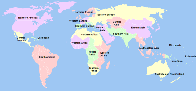
Created by User:Ben Arnold, edited by User:E Pluribus Anthony, from Image:BlankMap-World.png. Information about geographical subregions was obtained from Standard country or area codes for statistical use (M49). b/ The continent of North America (003) comprises Northern America (021), Caribbean (029), and Central America (013).
SVG
See the SVG-files File:Geografiaj subregionoj laŭ Unuiĝintaj Nacioj eo.svg (labelled in Esperanto) and File:Geografiaj subregionoj laŭ Unuiĝintaj Nacioj malplene.svg (blank) in better graphical quality.

|
Please translate the English parts of this template into Georgian.
არსებობს ამ გამოსახულების ვექტორული ანალოგი ("SVG"). გთხოვთ გამოიყენოთ იგი, რადგანაც მისი ხარისხი გაცილებით მაღალია. File:United Nations geographical subregions.png → File:United Nations geographical subregions en.svg
ვექტორულ გრაფიკაზე ინფორმაციის მისაღებად, გთხოვთ იხილოთ ფაილების SVG ფორმატში გადაყვანის ინსტრუქცია. ასევე არსებობს ტექნიკური ინფორმაცია ფორმატ SVG-ის მხარდაჭერის შესახებ MediaWiki-ში. |
 |
.png)
.svg)
.svg)
ლიცენზია

|
თქვენ შეგიძიათ გაავრცელოთ ან შეცვალოთ დოკუმენტი GNU Free Documentation ლიცენზიის 1.2 ან უფრო გვიანდელი ვერსიის პირობების თანახმად, რომელიც გამოქვეყნებულია თავისუფალი პროგრამული უზრუნველყოფის ფონდის მიერ, შეუცვლელი განყოფილებების გარეშე, პირველ და ბოლო გვერდებზე განთავსებულ ტექსტებზე. ლიცენზიის ასლი არის განთავსებული განყოფილებაში სახელად GNU Free Documentation License. |
| ეს ნამუშევარი ვრცელდება Creative Commons Attribution-Share Alike 3.0 Unported ლიცენზიით. | ||
| ||
| ეს ლიცენზირების ნიშანი დაემატა ამ ფაილს, როგორც GFDL ლიცენზიის განახლების ნაწილი. |
| date/time | username | edit summary |
|---|---|---|
| 18:33, 23 December 2005 | E Pluribus Anthony | (<span class="autocomment"><a href="/wiki/Image:United_Nations_geographical_subregions.png#Summary" title="Image:United Nations geographical subregions.png">→</a>Summary -</span> ed - corrected colourising of <a href="/wiki/Africa" title="Africa">African</a> countries) |
| 11:20, 5 November 2005 | Ben Arnold | (Created by <a href="/wiki/User:Ben_Arnold" title="User:Ben Arnold">User:Ben Arnold</a> from <a href="/w/index.php?title=Image:BlankMap-World.png&action=edit" class="new" title="Image:BlankMap-World.png">:Image:BlankMap-World.png</a>. Information about geographical subregions was obtained from http://unstats.un.org/unsd/methods/m49/m49regin.htm.) |
ფაილის ისტორია
დააწკაპუნეთ თარიღზე/დროზე ფაილის დასათვალიერებლად, როგორც ის მაშინ გამოიყურებოდა.
| თარიღი/დრო | მინიატიურა | ზომები | მომხმარებელი | შენიშვნა | |
|---|---|---|---|---|---|
| მიმდინარე | 04:20, 21 დეკემბერი 2012 | | 1 357×628 (81 კბ) | wikimediacommons>Spacepotato | Revert to the version of 14 Jan, since in the current version of the UN geographic classification scheme, http://unstats.un.org/unsd/methods/m49/m49regin.htm , South Sudan has been placed in Eastern Africa. |
ბმულები
ეს ფაილი არცერთ გვერდზე არ გამოიყენება.