ფაილი:Fault-Horst-Graben.svg

ამ SVG ფაილის PNG წინასწარი გადახედვის ზომაა: 534 × 274 პიქსელი. სხვა გაფართოება: 1 280 × 657 პიქსელი | 2 560 × 1 314 პიქსელი.
თავდაპირველი ფაილი (ფაილი SVG, ნომინალურად 534 × 274 პიქსელი, ფაილის ზომა: 20 კბ)
| აღწერა |
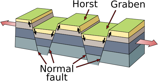
Deutsch: Vereinfachtes Blockdiagramm zur Veranschaulichung eines Horst-und-Graben-Systems in einer Dehnungszone. Die Halbpfeile geben die relative Bewegung an den Verwerfungen an. English: Simplified diagram depicting a horst and graben system in an extensional regime. The half-arrows indicate the relative movement along the fault planes. Español: Estructuras geológicas de horst (pilar tectónico) y graben (fosa tectónica). Galego: Macizo e fasa tectónicos Svenska: Geologisk skiss över horstar och gravsänkor. العربية : البنية الجيولوجية للنتق والأخدود |
||
| თარიღი | (UTC) | ||
| წყარო | |||
| ავტორი |
|
||
| სხვა ვერსიები |
[]
|


.svg)
| ეს არის რედაქტირებული ფაილი, რომლის ორიგინალი იყო ციფრულად დამუშავებული.ცვლილება შემდეგია: Redraw of pixel (jpg) image as vector (svg). ორიგინალი ინახება აქ: Horst graben.jpg. რედაქტირება მოახდინა Gregors.
|
This image is in the public domain in the United States because it only contains materials that originally came from the United States Geological Survey, an agency of the United States Department of the Interior. For more information, see the official USGS copyright policy.
|
ატვირთვის ჟურნალი
This image is a derivative work of the following images:
- File:Horst_graben.jpg licensed with PD-USGov-USGS
- 2008-12-06T13:29:23Z Woudloper 271x135 (41998 Bytes) {{Information |Description=Schematic cross-section through part of the upper crust under [[:en:extensional tectonics|extensional tectonics]] where [[horst]]s and [[graben]]s formed. |Source= |Date= |Author= |Permission= |othe
- 2005-12-13T17:48:12Z Angrense 346x260 (19398 Bytes) Diagram of a rift formation. Source: {{PD-USGov-Interior-USGS}} from http://earthquake.usgs.gov/image_glossary/horst.html
- 2005-08-25T17:36:54Z Slawojar 346x260 (19398 Bytes) geological structure of [[horst]] and [[graben]] {{PD-USGov-USGS}} [[:en:Image:Horst graben.jpg]] [[Category:Geology]]
Uploaded with derivativeFX
ფაილის ისტორია
დააწკაპუნეთ თარიღზე/დროზე ფაილის დასათვალიერებლად, როგორც ის მაშინ გამოიყურებოდა.
| თარიღი/დრო | მინიატიურა | ზომები | მომხმარებელი | შენიშვნა | |
|---|---|---|---|---|---|
| მიმდინარე | 16:40, 14 იანვარი 2025 | არ არის მინიატურა | 534×274 (20 კბ) | wikimediacommons>Lukask | File uploaded using svgtranslate tool (https://svgtranslate.toolforge.org/). Added translation for pl. |